Risk Maps for Plant-Protection Product Input into Surface Waters
Source: Agroscope
Agroscope Science | No. 126, 1-85, 2021
What are the possible routes of entry of plant-protection products into surface waters? Agroscope shows the potential input risks in terms of tile drainage, runoff and agricultural point sources for over 20 000 catchment areas.
The new Agroscope maps focus on tile drainage, runoff/erosion and point sources from farms (farmyard runoff). They enable identification of the high-input-risk catchment areas (CAs) – so-called ‘hotspots’ for the potential input of plant-protection products (PPPs). A total of 21,844 CAs with an average area of 200 ha were prepared and assessed by means of geographic information systems (GIS).
The maps serve to support responsible parties in the policy and administrative spheres, and to provide decision-making bases for regional projects and interested farm managers. The aim here is to minimise the risk of PPP entry into surface waters. The potential ecotoxicological risk of PPPs on catchment areas will be investigated in a follow-up project.
Catchment areas with PPP-relevant areas
PPP use must be expected on 40% of the utilised agricultural area or UAA (= ‘PPP-relevant areas’). These areas are used as arable land, or for permanent crops. PPP-relevant areas occur in nearly half of all CAs. A total of 1095 CAs are regarded as potential problem areas owing to their high percentages of PPP-relevant areas. We distinguish between three routes of entry: tile drainage, runoff/erosion and agricultural point sources.
The ‘tile drainage’ entry route
A good half of the drained area of Switzerland is PPP-relevant area. A total of 6281 CAs have drained PPP-relevant areas. In the case of 104 CAs, the majority of the area is affected. These CAs are mainly located in western Switzerland, and their surface waters could be particularly at risk in terms of PPP inputs via tile drainage.
The ‘runoff/erosion’ entry route
Twenty per cent of the UAA of Switzerland consists of PPP-relevant areas with watercourse connection at risk of PPP inputs via runoff and erosion. A total of 8939 CAs have PPP-relevant areas with watercourse connection, with a majority of the area being affected in 102 CAs. These CAs are mainly located in western Switzerland, and their surface waters could be particularly at risk in terms of PPP inputs via runoff and erosion.
The ‘agricultural point sources’ entry route
The evaluation shows that 3590 CAs are to be found in the three highest PPP risk categories. In many CAs there are thus a number of farms with an increased risk of PPP inputs via farmyard runoff.
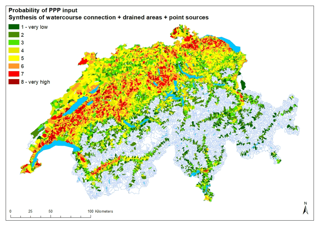
Synthesis map
In addition to the risk maps for the three routes of entry, a synthesis map was also created which shows where the main risk areas for potential PPP inputs are located as a whole: in the Swiss Central Plateau, particularly in western Switzerland, in the region of the Lucerne Central Plateau lakes, and in northeast Switzerland as well as the front Rhone Valley.
Detailed map
In addition to various national survey maps classified at CA level, there are also GIS maps with precise details of area. Such details would not be displayable in the survey maps. Detailed maps allow the closer inspection of individual CAs.
Conclusions
- Just under half of the mapped catchment areas have PPP-relevant areas.
- Catchment areas at high risk of PPP input via drainage tiles and/or runoff/erosion are located primarily in the Swiss Central Plateau, especially in western Switzerland.
- In many catchment areas there is a high potential risk of PPP inputs through agricultural point sources via farmyard runoff.
- Around 10% of the catchment areas are in the three highest assessment categories in terms of overall PPP input risk. Here, there is a high potential risk of PPP input into surface waters.
Bibliographical reference
Risk Maps for Plant-Protection Product Input into Surface Waters